How cold is it in Finland?
Reading time: 5 minutes
Finland is one of the largest countries in Europe, covering about 338,000 km², similar in size to Germany, and stretching from the Baltic Sea to almost the Arctic Ocean in a north-south direction. That is why Finland has a wide range of climatic conditions. This article will introduce the specific characteristics of different regions of Finland.
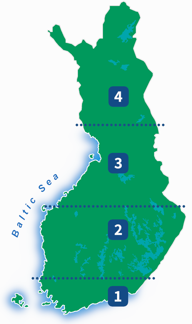
Finland can be divided vertically into four different climate types, which you can see in the diagram:
- Southern Finland
- Central Finland
- Northern Finland
- Lapland
Since Finland is located in the Northern hemisphere, it means that it is colder in the north and warmer in the south. Country is about 1000 km long, so this really matters.
The Arctic Circle runs through Finnish Lapland, just north of Rovaniemi. This means that in midwinter the sun does not rise at all during the day to the north of it (polar night), and similarly in midsummer the sun does not set below the horizon at night. This is called the midnight sun.
Another thing that greatly influences Finland's climate is the Baltic Sea. In winter it warms the climate, and in summer it cools it. The sea keeps coastal areas milder in winter because it stores heat and releases it slowly, even when covered by ice. The nights on the coast are also warmer in summer than inland.
Regions
These are two reasons why Southern Finland is the warmest area. Summer there lasts 125–135 days. There are more fields than elsewhere in Finland, and of the deciduous trees common in Europe, oak and ash grow only in this area in Finland. In winter, there is snow on the ground for 80–130 days, from late December to the end of March.
Southern Finland has the highest population density in Finland, and the capital, Helsinki, is also located there. Half of Finns live south of the bottom line on the map. As we can see, the line is well to the south. The geographical center of Finland is about 300 km further north.
Central Finland is the next area on our map. It could be described as the most basic landscape of Finland. Geographically, the region is divided into two parts: the Eastern Lake District and the Western Plains. In terms of climate, the western region has a maritime climate and the eastern region has a continental climate. This means that in the east, the temperature variation is greater and there is more snow in the winter. Summer lasts 110–130 days. A significant proportion of the Finns live in the region, and several large cities are located there: Tampere, Jyväskylä and Kuopio.
The third region on our map is Northern Finland. Climatically, the region is divided in the same way as Central Finland. The eastern part is a rolling highland, while the coast is low and flat. Many deciduous trees common in Central Finland, such as maple and linden, do not thrive in this area, and grain cultivation is only possible on the coast and in river valleys. Summer lasts 90–110 days. The region has only one large city, Oulu (216,000 inhabitants).
The coast of Central and Northern Finland is separated from the eastern part by a highland area known as the Suomenselkä, approximately 300 km long.
The northernmost region is Lapland, which is the coldest region. Small areas in the northernmost Lapland are treeless, or tundra. Siberian spruce is more common in Lapland than European spruce, which is the only spruce species found elsewhere in Finland. In Lapland, summer lasts only 50–90 days and there is polar night in midwinter. There is snow on the ground for 190–220 days, from late October to April. Snow can be a meter deep or more. Lapland has few settlements. The largest city is Rovaniemi with 65,000 inhabitants.
Temperatures
Finland's temperature is greatly influenced by its location, mostly between 60° and 70° north latitude (same as Alaska), and the Gulf Stream, which flows in the Atlantic, which raises Finland's temperature in winter by about 6–11 degrees compared to other northern regions. The Baltic Sea and the large lakes also raise winter temperatures. The annual average temperature is 5.5 °C in southwestern Finland. The average decreases as you move northeast, but is lowest in the northwestern parts of the country, where it is about −2 °C.
This may sound cold, but what does it mean in practice? Let's take an example: On the south coast, the highest daily temperature in July in Helsinki is an average of 21.5 degrees and the lowest is 14.2 degrees. The sea water temperature in the Helsinki area in July is 14–25 degrees. The coldest month is February, when the highest daily temperature in Helsinki is an average of -1.9 degrees and the lowest is -7.4 degrees. The sea is frozen.
In Finland, there are an average of 16 days in July when the temperature rises above 25 degrees somewhere in the country. Temperatures above 25 degrees can occur from the beginning of May to the beginning of September. In winter, temperatures in Lapland can be as low as -40 degrees, but on the south coast they rarely fall below -20 degrees.
Records
Because Finland is a long country, temperature differences can also be large. The highest temperature measured in Finland is 37.2 °C (in 2010) and the lowest is -51.5 °C (in 1999). The difference is 88.7 degrees Celsius.
Winds and cloudiness
Strong winds are not common in Finland and are especially rare inland. Inland, the average wind speed is 3–4 m/s and on the coasts and sea areas 5–7 m/s. The windiest period is from October to January and the least windy is from April to July.
Cloudy days are more common in Finland than clear days, and in winter the cloudiness is up to 65–85%. The clearest period is usually in May–June, when the cloudiness is around 30–40%. July is the rainiest month of the year inland, while on the coast it is not until August.
When to come to Finland?
Finland has four distinct seasons. The long, cold winter in the north and the warm summer in the south offer opportunities for different types of experiences. However, it is important to remember that not all summers are the same. When vacationing in Finland in the summer, it is always worth being prepared for the fact that the weather can also be cool, windy or rainy.
Best time to come
July and August: This is the warmest time of the summer in Finland and everything is green. There are many different events and people are on the move. In the summer, many Finns head to their cottages in the countryside. In June–July, you can experience a midnight sun in Lapland.
February and March: The best time for winter sports is from February to the end of March. The coldest and darkest part of winter is over. There is usually snow all over the country, including Southern Finland, and the days are often sunny. You can see the northern lights in Lapland and Northern Finland.
Worst time to come
October and November: The weather is damp, cold and cloudy. November is not the coldest month, but the combination of cold and humidity makes the air feel chilly. Strong winds are common. The daylight hours are already quite short.
April:The snow has melted almost everywhere, but the trees still have no leaves. The weather can be warm or cold, but it is usually dry. The sand of winter sprinkling makes the air in cities dusty. In rural areas, gravel roads can be in poor condition.
Sources
Finnish Meteorological Institute: Seasons in FinlandWikipedia: Climate of Finland
Finnish Meteorological Institute: Helletilastot
Finnish Meteorological Institute: Tilastot
Seatemperature.net: Helsinki